We often see rivers as simple blue lines on a map, tranquil bodies of water that are nice for a picnic or a boat ride. But this perspective misses the colossal power humming within their currents. A single, persistent river is one of the most potent forces on our planet, a geological artist and an ecological engineer with the power to sculpt the very face of a continent over millennia. They are not merely features on the landscape; in many ways, they are the creators of the landscape itself, dictating where mountains erode, where plains form, and ultimately, where life can flourish.
The Grand Sculptor: How Water Shapes Stone
The most dramatic work of a river is etched in stone. Its primary tool is
erosion, a relentless process of wearing away rock and soil. A river acts like a massive, slow-moving belt sander. It picks up sand, pebbles, and even boulders, using this abrasive sediment to scour its own channel deeper and wider. This isn’t a fast process by human standards, but on a geological timescale, it performs incredible feats of engineering. The most iconic example is the Grand Canyon in the United States, a vast chasm carved by the Colorado River over millions of years. The river didn’t just cut a simple ditch; it sliced through layer after layer of rock, exposing a billion years of Earth’s history for all to see.
But a river is not just a force of destruction; it is also a master builder. Everything it carves from one place, it must eventually drop in another. This process is called
deposition. As a river’s current slows, typically as it approaches a large lake or the ocean, it loses the energy required to carry its sediment load. The heaviest particles drop first, followed by the lighter ones. Over eons, this dropped sediment accumulates to create entirely new landforms. The most significant of these are river deltas. The Nile Delta, for example, is a massive, fan-shaped area of fertile land built from sediment carried all the way from the highlands of central Africa. This deltaic land is not just an extension of Egypt; for thousands of years, it has been the very foundation of its civilization and agriculture.
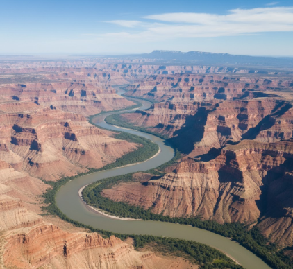
From Meandering Bends to Vast Floodplains
The journey of a river from the mountains to the sea is rarely a straight line. In flatter regions, rivers begin to snake back and forth in looping curves called meanders. The water on the outer edge of a bend moves faster, causing erosion and cutting into the bank. On the inner bend, the water is slower, leading to deposition. This process causes the meanders to become more and more exaggerated over time, and occasionally, the river will cut a new, straighter path, leaving behind a curved remnant known as an
oxbow lake. This constant shifting and reshaping of its own path create a wide, flat valley known as a floodplain. While these areas are prone to flooding, the silt and nutrients deposited by the floodwaters create exceptionally fertile soil, making river floodplains some of the most productive agricultural lands on Earth.
A single river system performs a dual role in continental transformation. It relentlessly erodes highlands and mountains, carrying away billions of tons of rock and soil. Simultaneously, it uses that same material to build new landforms like deltas and floodplains. This continuous cycle of erosion and deposition is a fundamental geological process that shapes coastlines, creates fertile valleys, and dictates the physical geography of entire regions.
The Ecological Architect
A river’s influence extends far beyond geology. It is the backbone of entire ecosystems. The river and its surrounding basin create a mosaic of different habitats, from the cold, fast-flowing, oxygen-rich streams in the mountains to the warm, slow-moving, nutrient-rich waters of the lowlands. This variety supports an incredible diversity of life. The Amazon River Basin is the ultimate testament to this. The river and its countless tributaries sustain the largest rainforest on the planet, a region that is home to an estimated 10% of the world’s known species. The river isn’t just a source of water; its annual floods are a critical event that pulse nutrients through the forest, sustaining a web of life of unimaginable complexity.
Think of a river as a continental-scale conveyor belt. It transports more than just water; it moves a constant stream of nutrients, organic matter, and life itself. Seeds are carried downstream to colonize new areas. Fish migrate hundreds of miles to spawn. The dissolved minerals and rich silt it carries from the interior are not just for building deltas; they are a vital source of nutrients for coastal estuaries and marine ecosystems. This flow connects the health of the deep continental interior directly to the health of the oceans, demonstrating that no ecosystem exists in isolation.
The Artery of Civilization
It is no coincidence that the first great human civilizations all sprang up on the banks of major rivers: the Nile in Egypt, the Tigris and Euphrates in Mesopotamia, the Indus in Pakistan, and the Yellow River in China. Rivers provided all the essentials for a settled society: a reliable source of drinking water, fish for food, and, most importantly, water for
irrigating crops. The predictable annual floods of rivers like the Nile deposited fresh layers of fertile silt, guaranteeing bountiful harvests year after year. This agricultural surplus allowed populations to grow, cities to form, and complex societies to develop.
Long before roads and railways, rivers were the world’s first superhighways. They provided a relatively easy means of transport for moving people and heavy goods. Rivers enabled trade, exploration, and the expansion of empires into continental interiors. In North America, the Mississippi-Missouri river system was the main artery for westward expansion, allowing explorers, trappers, and settlers to penetrate deep into the continent. Cities like St. Louis, Memphis, and New Orleans grew into major commercial hubs precisely because of their strategic locations along this vast waterway. Even today, rivers remain vital commercial arteries around the globe. This role in human movement also means rivers are powerful vectors for the spread of ideas, culture, and language, weaving together the human fabric of a continent.